OGIA has developed a number of products and tools that can be used to find information that may be of interest. OGIA will continue to develop new tools, and improve these existing tools, incorporating new information, data and research and making these available to the public.
Bore search tool
This tool allows users to search for specific information about the predicted groundwater impacts at the location of a bore by entering the bore's registration number (RN) in the search box below.
There was an error loading this content. Please contact us if this issue persists.
Loading...
Bore number not found
Sorry, we could not find a bore matching the RN number you have entered. Make sure you have entered the correct number.
Note that only bores which were registered in the DRDMW groundwater database in early 2021 and which are located within the Surat CMA are listed in this bore search tool. Recently registered bores may not be listed.
Bore Registered Number RN {{ bore.RN }}
Information presented below is based on the assessment provided in the Surat Underground Water Impact Report 2021 which was approved on 17 March 2022.
This bore was identified as an Immediately Affected Area (IAA) bore in a previous UWIR. Based on the information available to OGIA as of May 2021, a bore assessment and a make good agreement have been completed by {{ bore.RTH }}. bore assessment is completed and a make good agreement is in progress or pending by {{ bore.RTH }}. bore assessment by {{ bore.RTH }} resulted in changes to the bore information; as a result, the bore was subsequently determined not be an IAA bore. bore assessment is required by {{ bore.RTH }} and is currently pending.
This bore is identified as an Immediately Affected Area (IAA) bore in the UWIR 2021 and the responsible tenure holder for the follow-up bore assessment and make good agreement is {{ bore.RTH }}.
This bore is identified as a Long-term Affected Area (LAA) bore in the UWIR 2021.
Based on the current development scheduling, the bore is likely to be identified as an IAA bore sometime between 2025 and 2027.
This bore has been proactively entered into a make good agreement.
This bore is not predicted to be an impacted bore in the UWIR 2021, but the bore is located in the Long-term Affected Area (LAA) footprint of another formation.
No impacts are predicted at the location of this bore.
This bore is recorded as abandoned, could not be found or decommissioned.
Physical status of the bore
The verified location of this bore is recorded as {{ bore.Latitude }}, {{ bore.Longitude }}.
Baseline assessment and/or a bore assessment has also been completed. Based on the verification of this information, the bore is found to be {{ bore.BORE_STATUS.toLowerCase() }}.
This bore is recorded as having been replaced by RN {{ bore.Replace_RN }}.
Information recorded in the GWDB suggests that the bore is {{ bore.BORE_STATUS.toLowerCase() }}.
If you have data that suggests otherwise, please contact OGIA to provide that information in order to correct the record.
Source aquifer for the bore
The bore is screened across the following aquifer(s): {{ bore.AA_Formation }}
The bore is at least partly sourcing water from the {{ bore.Formation }} (source aquifer or attributed aquifer). This is based on the available bore construction information, depth of geological formation from OGIA’s 2021 geological model, information recorded in the groundwater database, bore and baseline assessments where available, site verification where available and further desktop verification of bores in priority areas. As a result, in some instances, OGIA’s aquifer attribution may differ from the formation assigned in a water licence.
This bore has high quality construction information and the bore inlet intersects an area of high confidence in OGIA’s geological model. High confidence areas are those locations within 15 km of a geological model control point.
This bore has moderate to high quality construction information and the bore inlet intersects a lower confidence area in OGIA’s geological model. To assign the screened aquifer(s), the bore is further intersected with GWDB aquifer and stratigraphy tables, where available. Or where the GWDB aquifer and stratigraphy tables are incomplete, information from RDMW’s water licencing database is used, where information is available, to assign the screened aquifer(s).
This bore has low quality construction information and is missing depth or inlet information. As such the bore is assumed to be screened in the dominant aquifer intersected by other water supply bores in the nearby area, or an intake is generated using data from other bores constructed to a similar depth and at similar time.
Prediction of impacts
Predictions of impacts on this bore are based on the existing CSG, petroleum, gas and coal development, and the current plans for future development (refer to the UWIR 2021 for more details).
The UWIR 2021 short-term impact at this bore is less than 5 metres.
Predicted impact in the source aquifer at this bore location at the end of 2024 is {{ toDecimal(bore.IAA_DD, 2) }} metres. Since the bore is sourcing water from an consolidated unconsolidated formation, this impact is at or above the 5 metre 2 metre threshold; making it an IAA bore.
The maximum impact at this bore is predicted to be {{ toDecimal(bore.Max_DD, 2) }} metres {{ bore.Predicted_Period }}.
The responsible tenure holder {{ bore.RTH }} is required to carry out a bore assessment to establish whether the predicted impact will result in actual impairment of the bore water supply and, if necessary, enter into a make good agreement with the bore owner (if an agreement is not already in place).
This bore was constructed and completed after 2011 when the first UWIR (UWIR 2012) was released for consultation. The bore is therefore likely to be considered a ‘New Bore’ under s412(2) of the Water Act 2000 for the purpose of make good arrangements.
Long-term predicted impact in the source aquifer at this bore location is {{ toDecimal(bore.Max_DD, 2) }} metres. Since the bore is sourcing water from an consolidated unconsolidated formation, this impact is at or above the 5 metre 2 metre threshold; making it an LAA bore.
Based on the current development scheduling, the bore is likely to be identified as an IAA bore sometime between 2025 and 2027.
OGIA has received information that indicates this bore has been entered into a make good agreement prior to becoming an IAA bore.
Tenure holder contact details:
Arrow Energy: phone 1800 038 856 or email info@arrowenergy.com.au
Origin/APLNG: phone 1800 526 369 or email contact@aplng.com.au
QGC: phone 1800 030 443 or email QGC contact form
Santos/GLNG: phone: 1800 761113 or email community@santos.com
Senex Energy Limited: phone: 1800 811 165 or email info@senexenergy.com.au
Finding a bore's registration number
You can use the Queensland Globe to find a bore's registration number (RN):
- use the Layers menu to add the "Registered water bores (DRDMW and private)" layer.
- use the Search menu to find your property and see the bore number.
If you are the owner of a bore in the Surat CMA, you can also contact the Department of Regional Development, Manufacturing and Water for help finding your bore number. You will need the lot and plan details for your property, which can be found on the rates notice for the property.
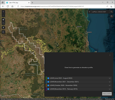
LiDAR tool
OGIA’s interactive web-based LiDAR tool allows users to query land profiles from LiDAR data in the western parts of the Condamine Alluvium. This image shows the LiDAR tool in a browser window.
LiDAR stands for "Light Detection and Ranging". It is a technology that uses light signals to measure distances to objects and create three-dimensional maps of landscapes. LiDAR can be used to create detailed maps of terrain, buildings, vegetation and other features.
Since 2021, OGIA has been using data received from aerial LiDAR surveys to help assess the impact of CSG induced subsidence in the Surat CMA. The surface drainage pattern across a paddock can be derived from an aerial LiDAR survey. It also helps to identify minor slopes and depressions that can be used to determine CSG-induced subsidence in the future.
Tenure holders in irrigation areas in the Surat CMA provide OGIA with LiDAR data at least once a year as part of the regional subsidence monitoring program.
Aquifer attribution
Identifying the attributing aquifer from which a water supply bore sources water is a critical piece of information required to support the assessment in the UWIR. The aquifer attribution process uses a range of data and analysis about the location and construction details of water bores, as well as the geological model developed by OGIA. Assumptions are made where some or part of the information about bore construction is not available.
Note: the aquifer attributed to a water bore may change when underlying data changes due to ongoing improvements.
Last updated: 04 Oct 2023